Yosemite
We decided to plan a Yosemite trip in the fall of 2016 for summer 2017. It is crucial to plan Yosemite trips far in advance for reservations! Backcountry permits are very limited.
After researching the hikes, I decided it would be best to hike from Tuloumne Meadows to Yosemite Valley as we would overall be losing elevation. I faxed in our request the second possible day, 163 days in advance. I received a call from a ranger asking how we felt about snow as it would be likely we would encounter some above 7,000 foot elevation. At the time, we were not worried about the snow.
However, months later, Yosemite ended up with 220% more snow than the previous year. Unfortunately, it looked like Tioga Road would not be open in June, therefore we would not be able to reach the trailhead.
We changed our plans in April which did not leave much time. The only available options was to hike Happy Isles to Illilouette Falls area. That was definitely not my first choice but we knew we needed to make it work and have a good attitude about it! We had our itinerary worked out and decided we would drive from San Francisco to Yosemite and stay in the Backpackers campground. They allow you to stay there 1 night before and after your trip. When you arrive at the park, it takes a long time to get to the valley. The drive is beautiful though! We stopped at Bridalveil Falls on the way to the campground.


From left to right: Bridalveil Falls on the way to camp, creek at the backpacker's camp, Yosemite Falls on the drive to camp
By the time we entered the valley, the backcountry office was closed. This stressed me out because you are supposed to have your permit on you in the backpacking campground. At one point a ranger even approached us and I was concerned they would question me! They were simply making sure we knew bear safety and let us know to be very careful hiking Mist Trail as someone had slipped recently and fell to their death. One problem we had was finding parking. We unloaded our car and carried our things into the campground but had to park far away in the dark. We went to bed without eating a real dinner, unless you consider cereal?! I wanted to wake up early to see Glacier Point. The road was open and there were hardly any people there this time of year. It was very cold and there was even snow in June!

Tunnel view on the way to Glacier Point


Views from Glacier Point
After Glacier Point, we went to get our backpacking permit, bear canisters, and fuel for our camping stove. Yosemite's visitor center was under construction so parking was difficult. We ended up parking far away and it took a long time to find the backcountry office! There were many other confused people so I suppose I felt better not being the only one. We waited in a short line and obtained our permit and bear canisters. The ranger told me distances that were grater than what I had researched for our hiking itinerary. It is also confusing because you have to hike out of a zone (they don't want you camping too close to the valley) but the zone is not marked on the actual hiking trails so it is sort of a guess.
We went to purchase the fuel only to discover they were sold out. So, we went to the next store and guess what? Sold out! Our final option was the Mountain Shop at Half Dome Village store. Thankfully they had 2 cans of fuel left! We purchased our fuel for our stove and quickly headed back to our campsite. At this point, we wasted a lot of time and were eager to get hiking. Thankfully, my fiance had packed up camp while we were running around. We headed to the parking area and then decided to take a shuttle to the Happy Isles trailhead. We found a parking spot quickly since it was a weekday and still early enough that the crowds had not arrived. It took a long time to pack our backpacks and ensure we had all of our supplies. Unfortunately, it was getting hot and my fiance's diabetes supplies immediately came off. This was very concerning! We weren't sure if he would be able to even come with us in the backcountry. Without a reliable source of insulin, he could die.
Andrew decided he would go into the backcountry but we all decided that if need be, we would come back to the valley and not continue if the injectable insulin was not working. We waited on the shuttle; however, the first two were full! We were already losing a lot of daylight so we decided to walk a mile to the trailhead. Almost no one was carrying a pack and it was steep! I am not going to lie, our spirits were dwindling by the end of that day. The sun had begun setting when we arrived at Nevada Falls. We realized that we missed where the trail split as it is just before you get to the top of Nevada Falls. We turned around and found it.
**Note: there are not always trail signs where the trail splits and some of the backcountry trails are not named. It can be easy to miss your trail without signs directing you. Where our trail split, it was a series of switchbacks with a lot of elevation gain. We were at one of the switchbacks when I heard something and thought it might be a deer. It turned out to be a black bear.


Andrew talking to a family from Chillicothe, Ohio and Our campsite the first night
As I mentioned, you have to camp out of the purple area (outside of little Yosemite valley) on the map but on the trails, that is not marked so you have to estimate it. We ended up hiking quite a bit more than I had estimated the first day, and the elevation was greater too. We were all so tired and anxious to set up camp. We found a sandy site that had a fire ring so it appeared others had previously used this spot. We decided to pitch the tent and skip a real dinner that night. We had another long day ahead of us and decided to get hiking and then stop to eat when we refilled our water. Yosemite was the first time I had to filter water from a natural source. In Alaska and the Grand Canyon, we carried all of our water ourselves and refilled when we could. In Yellowstone, we weren't doing a thru hike or a long out and back so we did not need as much water. Andrew set up the filter and it worked really well! We were all in better spirits once we had all the water refilled and ate breakfast.


Left: My Dad and Andrew filtering water on the way back towards Nevada Falls.
Above: one of the trail signs, although some junctions did not have any signage
We stopped back at Nevada falls to take some photographs and videos. The rushing water was so powerful. There are many signs warning people not to wade in the water as you often get swept away. We were in the same spot as the previous night when we realized we missed the trail split. There is an outhouse close to Nevada falls. The next portion of the trail was flatter, which was a welcomed relief. We stopped at the Little Yosemite Campground to eat our lunch. The campground was mostly empty this morning as many campers went hiking or not yet arrived. There was also a restroom so we took advantage of it and went on our way.


We took a break at the trail split for Half Dome. There was a large, guided hiking group that were also resting. It was nice getting to know them for a short while. We then continued towards Cloud's Rest and oh my the switchbacks! There were MANY switchbacks. We were getting concerned that we might not find a flat area to camp that night. Andrew and I disagreed on what to do. I wanted to continue hiking up the trail towards Clouds Rest and set up camp. He wanted to drop our bag, summit, and then grab them and find a spot down the trail. I did not want to be rushed trying to get to the top as we really did not know what to expect. We did pass a hiker that described a flat area towards the end of the switchbacks. It got to a point where we were counting down the switchbacks we counted on the map. Finally, the trail opened up and we had a fantastic view with our camping spot for the night!


Camping site in the backcountry, down from Clouds Rest. Views of Half Dome and the Sierra Nevada Mountains.
It was wonderful having our camp set up long before dark. We ate a good dinner and went to bed early. The next morning, we all woke up early to hike up Cloud's Rest. It was cold! The snow was frozen again, which made it very difficult to hike without crampons. It was also difficult to find the trail with all of the snow. We were fortunate when we made it to the top to have unobstructed views as long a month or so later, the park was covered in wildfire smoke.


Hiking up snow on Clouds Rest


Views from atop of Clouds Rest: Half Dome, Sierra Nevada Mountain Range

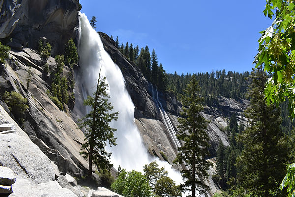
We had a quick descent to the valley. In all, we did 12 miles the last day to return to the car. We saw a side view of Nevada Falls and kept remarking that we were thrilled that we weren't going uphill any longer. It is a steep climb. We took Mist Trail to see Vernal Falls. I thought it was wonderful but my Dad and Andrew did not enjoy this portion. The trail was crowded and very slippery! A man who routinely took this trail fell off a few days prior to our trip and was killed. I used caution and did not get too close to the edge. The falls sprays you as you walk by, which was welcomed considering it was getting warm. When we arrived back at our vehicles, the parking lot was packed. We had someone ask us every 30 seconds or so if we were leaving so they could have our parking spot. One group even offered to pay us for it. We headed back to San Francisco for our red eye Frontier flight back home.